
WILLMAR—The centerpiece of the lobby/commons area at Willmar Senior High School is a map of the globe dotted with pins marking students’ birthplaces.
The entire commons area has a new look this fall, with a case displaying student artwork and the globe mounted on the wall near the guidance office and large letters spelling out “Willmar Cardinals” mounted near the office.
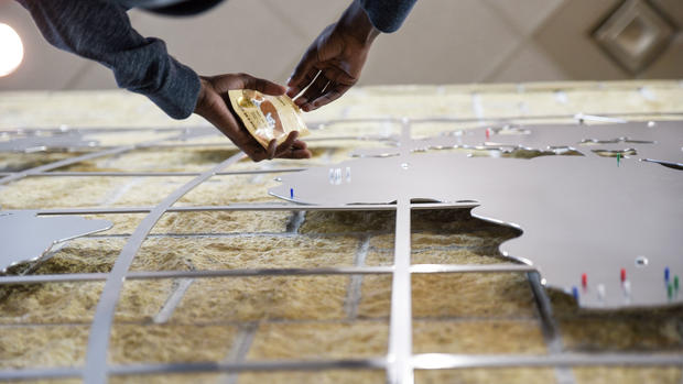
The magnetic pins on the map show the birthplaces of the school’s 1,300 students. A Willmar Cardinals sticker is placed over Willmar, where there isn’t enough room for all the individual pins.
Principal Paul Schmitz said he was looking for a way to update the commons area. He didn’t like the faded, aging signs hanging there.
Schmitz said he conducted an experiment—he walked around the school with a $5 bill in his hand and offered it to anyone, teen or adult, who could tell him what the signs said. He still has his $5. That told him the signs needed to go.
Schmitz said he borrowed an idea from Willmar Middle School counselor Jeff Winter, who painted a map of the world on the counseling office wall years ago. Winter has students place pins on their birthplaces, too.
“I decided we need our own version of it,” Schmitz said.
That’s when West Central Steel stepped in, along with a couple other area businesses. The company worked with Schmitz on the design and donated the steel. The final 12-by-8 map was laser-cut from a single sheet of metal, said Jon Lindstrand, drafting and scheduling coordinator for West Central Steel.
Lindstrand said he worked with Schmitz for several weeks to develop the design and overcome some logistical challenges.
Latitude and longitude lines help keep the map together and anchor the continents and island nations, said Bill Pattison, West Central Steel’s director of business development.
The finished sign was a group effort. After the laser cut at West Central Steel, Hanson Silo Co. of Lake Lillian powder-coated and painted it, and Quick Signs of Willmar helped with the mounting.
Using a single sheet of steel made the map easier to mount on the wall, but it was a little more difficult to handle and transport, the men said.
The hope is that it will last a long time, Pattison said.
“We certainly appreciate and like supporting the high school, the kids in the area, and making sure they have the things they need to help develop and learn,” Pattison said.
School counselor Megan Erickson worked with students to place the pins. Students were surveyed, and she and a group of students plotted a map. “It really represents our diversity,” she said.
One day after school, Erickson and her student helpers spent about two hours. One person climbed a ladder and others stood below with maps, directing the placement.
The students who participated in the project said their classmates have admired the map and said they think it’s cool.
Each class has a different color pin—white for freshmen, blue for sophomores, green for juniors and red for seniors, Erickson said.
The map will always be a work in progress, she added. When seniors graduate, their pins will be taken down, and the color will be used for the next freshman class.
“Every pin represents one person, except in the Willmar area,” she said.
From Willmar the pins fan out across Minnesota and the country, with a large number in Texas. Nearly every continent has at least a few pins. Heavier concentrations are in Mexico, Central America, east Africa and southeast Asia.
“I definitely learned about my geography,” Erickson joked.
West Central Tribune by Linda Vanderwerf